

Flood Resilience - Case Studies of Success
Flood resilient communities are those that can withstand natural disasters with minimal loss of life and property. Key components of flood resiliency include the ability for impacted residents to get back on their feet quicker than in previous events, ensuring that ecosystems are not significantly impacted during or after a flooding event, and that property damage is kept to a minimum.
Green infrastructure is a term to describe networks of natural spaces used to mitigate flood risks by slowing stormwater runoff while protecting floodplains. Some examples include:
Conserving and restoring riparian buffers
Floodplain sinks
Stream restoration
Rain gardens
Established native woodlands
Gray infrastructure is a term used to describe “traditional” infrastructure, which includes man-made materials such as concrete and steel. This type of infrastructure performs similar functions but for different purposes. Some examples include:
Dams
Seawalls
Water treatment plants
Stormwater pipes and drains
Beyond green and gray infrastructure, community development response efforts that focus on local preparedness and incorporate a whole-community approach to resilience are also important.
Below are a series of case studies that highlight the benefits of flood resilient infrastructure throughout the Appalachian region.

Stream Restoration
This is a foundational approach to nature-based solutions in Appalachia. Instead of channelizing streams with concrete, natural stream restoration focuses on returning degraded waterways to its native state.
Concept: Reconnecting the stream to its floodplain through techniques such as stabilizing banks with vegetation or other natural structures, adding meanders to re-establish natural streamflow, and improving natural habitats. This slows down water, increases infiltration, and reduces the peak flow downstream during heavy rain events.
Appalachian Example: Southern Appalachian Highlands Conservancy Community Farm

Forestry Reclamation Approach
Decades of coal mining have left a scarred landscape with highly compacted land, acid mine drainage, and altered hydrology, exacerbating regional flooding. Reclamation techniques, such as the Forestry Reclamation Approach (FRA), have a proven track record of success at reclaiming abandoned mine lands across Appalachia, most notably embodied by the Appalachian Regional Reforestation Initiative (ARRI).
Concept: Using science-based methods for reforestation, with a focus on high-value hardwood trees and functional ecosystems, the FRA rehabilitates coal-mined lands that benefit all.
Appalachian Example: The Monongahela National Forest

Riparian Buffer Restoration
The forests along rivers (riparian buffers) are critical natural infrastructure. When these areas are cleared for development or agriculture, flood risks increase dramatically.
Concept: Protecting existing forested buffers and replanting ones where they have been lost over time due to erosion or human factors. The deep root systems of native trees and shrubs hold soil in place, absorb tremendous amounts of water, and slow overland flow. Riparian forest buffer zones also provide additional benefits for agricultural farmlands, too.
Appalachian Example: National Center for Appropriate Technology’s (NCAT) Southern Appalachian Riparian Buffers

Rain Gardens
In more urbanized areas of Appalachia, such as Huntington or Pittsburgh, small-scale green infrastructure can be aggregated to make a big difference. Rain gardens provide a helpful, low-cost resource for these communities.
Concept: A rain garden is a simple shallow depression in a yard that’s then planted with native wildflowers and grasses. Stormwater runoff causes significant water pollution and increases flood risks in cities across the region. Rain Gardens collect excessive rain water runoff reducing flood risks.
Appalachian Examples: Huntington, WV; Pittsburgh, PA
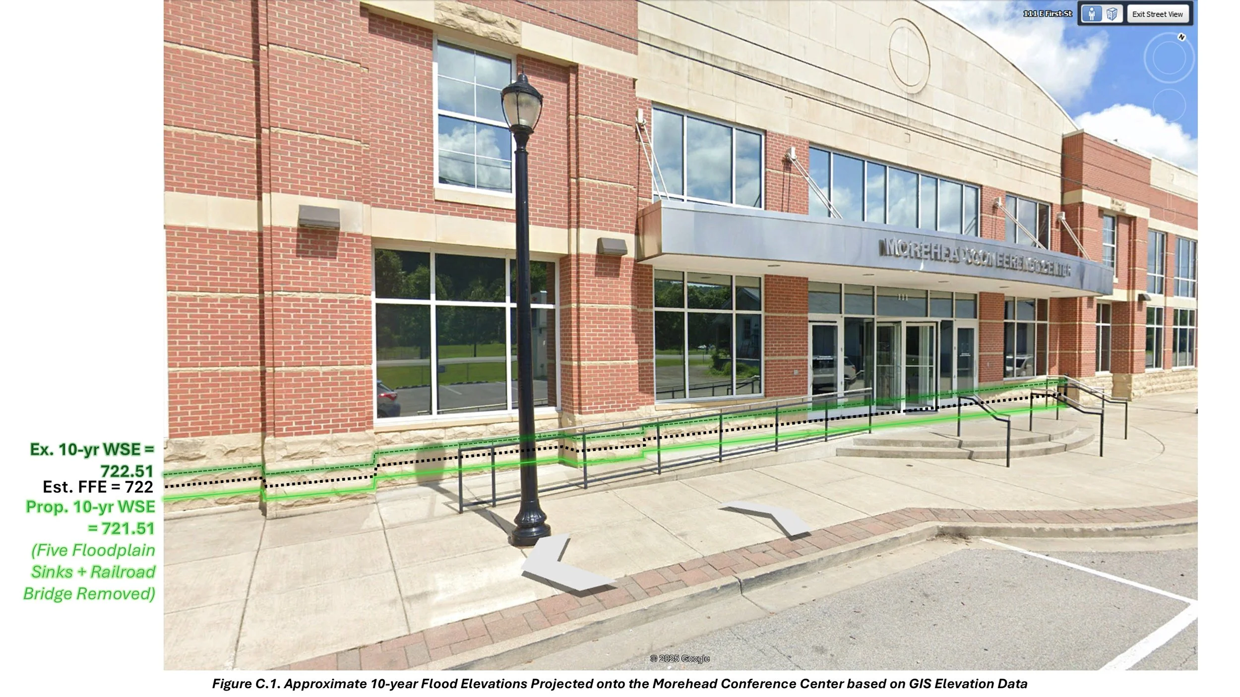
Floodplain Sinks
For many small communities across Appalachia, large-scale infrastructure projects to reduce flooding are economically unfeasible. However, floodplain sinks help to reduce flooding through basin construction.
Concept: Floodplain sinks are, in some ways, like large-scale French drains. They’re created by excavating land within the floodplain - between 1 to 5 acres with a depth of 2 to 4 feet above groundwater - that can redirect floodwater into a basin and away from areas of human habitation or infrastructure.
Appalachian Example: In August 2025, the City of Morehead, KY, received a report from Team Kentucky’s Energy and Environment Cabinet that outlined several floodplain sinks that could drop the water surface by several inches to a few feet for 100-year flood events. While planning and design funding has been identified through EPA 391h, FEMA planning grants, and USACE-PAS, construction for these floodplain sinks has yet to be allocated because of the rescission of BRIC funding to states.